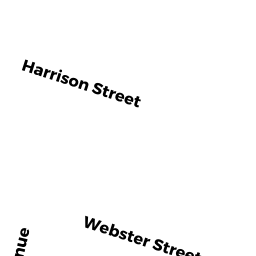
13 WEBSTER STREET
Owner Information
TAURAZAS RONALD A & MARY LOU TRS &
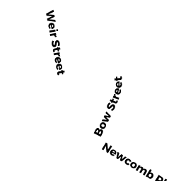
94 WEIR STREET
TAUNTON, MA 02780


Property Details
13 WEBSTER STREET is classified as a APT 4-8 UT M94 (Aptoldstyle 4-5 unts).
The primary structure on this property was built in 1900. There are 4,720ft2 of built area within this property. There is 3,324ft2 of residential/living space within this property.
13 WEBSTER STREET is valued at $395,500. The land is valued at $69,100 and the structures are valued at $326,400.
This property is in Zone 3.31. Confirm with local Zoning Board authorities to ensure there are no overlays or other easements on this property.
The most recent deed for 13 WEBSTER STREET is recorded at the local registrar in Book 22286, Page 0095. 13 WEBSTER STREET was last sold on Friday, May 15, 2015 for $1.
Assessment data from fiscal year 2021.
Flood Data
According to the FEMA National Flood Hazard Layer, this property does not appear to be in a flood zone. It may also be in an area not yet reviewed. Nonetheless, confirm this information prior to taking any action.
To view the flood hazards around this property, create a FEMA "Firmette" Map of the area around 13 WEBSTER STREET.
Broadband Internet Providers
| Provider | Type | Bandwidth (mbps) | |
|---|---|---|---|
| HughesNet | Satellite | 25 | 3 |
| Verizon New England Inc. | DSL | 10 | 1 |
| Verizon New England Inc. | Fiber | 940 | 880 |
| Viasat Inc | Satellite | 100 | 3 |
| VSAT Systems, LLC. | Satellite | 2 | 1 |
| Comcast | Cable | 1000 | 35 |
| GCI Communication Corp. | Satellite | 0 | 0 |
Broadband service provider data from December 2020.
Adjacent Properties
- 11 WEBSTER STREET
Three-Family Residential owned by MEDAS EDWARD W TR - 18 HARRISON STREET
APT 4-8 UT M94 owned by CABRAL JOSE/AKA/JOSEPH I - 22 HARRISON STREET
Two-Family Residential owned by LOPES MICHAEL TRS - 15 WEBSTER STREET
Two-Family Residential owned by RODRIGUES MANUEL A & LUCY L - 14 HARRISON STREET
APT 4-8 UT M94 owned by 14 HARRISON STREET LLC